Subway Shuttles of New York City

New York, like London and Hong Kong, has subway shuttle lines.  These lines, unlike the others in the system, shuttle between only two (or sometimes up to five) points on the system.  While many of the regular numbered and letter trains of the NYC subway system function as shuttle trains after hours, there are three dedicated shuttle services on the system: one in Brooklyn, one in Queens, and one in Manhattan.  The three services also correspond with the former subway companies that serviced the city: the BMT, IND, and IRT.

The Brooklyn service is the Franklin Avenue Shuttle.  This line links about two miles between Prospect Park and Franklin Avenue.  The train links BMT, IND, and IRT services together between four stops and provides a great way to get to Prospect Park and Bedford-Stuyvesant.  Once part of a late 1800s railroad, this shuttle was truncated in 1963.  Known for most of its history for its low ridership and accidents from time to time, the Franklin Avenue Shuttle was rebuilt extensively and is unique as it is the only line on the system that is single-tracked.  The service also uses two-car trains due to its diminutive ridership levels.

The Queens shuttle is important, linking a stop on Broad Channel to Rockaway Park, a distance of two whole miles being covered with only five stops.  This shuttle has been in operation since 1956 and connects some of the farthest-flung communities in the city to the rest of the system.  While the shuttle could be impacted by hurricanes (as happened during Hurricane Sandy), the Metropolitan Transportation Authority worked hard to bring the line back up to code and operational again.

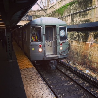
In terms of the shortest shuttle ride—and the most famous—there is the 42nd Street Shuttle.  This line operates at all times, excluding late nights, and covers 2700 feet in less than two minutes.  Originally part of the IRT subway line, the 42nd Street Shuttle was configured in 1918 and has kept its form since then. The shuttle’s line was part of the original IRT line that ran between City Hall and Lower Manhattan to 145th Street in Upper Manhattan via Grand Central and Times Square on 42nd Street (where the shuttle currently operates).  One of the more interesting proposals for the line that never came to pass was the idea to replace it with a conveyor belt system.  A fully automatic train was put into use on the shuttle for a brief time in the 1960s, but was withdrawn due to cost issues and a fire in the shuttle passage.  The shuttle today is known for its train interiors wrapped in advertisements, as it is one of the busiest in the system.

The shuttles on the NYC Subway are some of the more unsung heroes of the system.  Although they are not the subject of famous songs (such as Take the A Train), these lines help to alleviate pressure on the others of the network and to get people between lines more expediently.  The rides on these trains are also unique among the various subways of New York for their scenery and riders.  Catch the best tours of NYC (transit-focused upon request) with Sights by Sam.

Port Authority Bus Terminal

On the west side of Midtown is one of the most important transportation centers in the city. The very aptly-named Port Authority Bus Terminal (PABT) is managed by the Port Authority of New York and New Jersey. Its construction was meant to consolidate the various smaller bus terminals around the city into one unit, of which close to a dozen were believed to exist in the city limits at one point.

Constructed between 1950 and 1979, the PABT has 223 slips to allow large intercity buses to bring passengers into Manhattan. Many of these arrivals and departures are for New Jersey Transit commuter buses that bring thousands of commuters into the city from New Jersey. These commuter buses are bolstered by fleets of smaller buses (jitneys or vans) that help to bring in more people. Long distance buses from the East Coast and all over the country also call on PABT. During the morning, so many buses make their arrival into PABT, which is near the NY entrance to the Lincoln Tunnel, that the buses have an exclusive lane from the New Jersey side that brings them directly to the terminal.

With the proliferation of Chinatown buses and other transportation providers operating (sometimes illegally) curbside bus pickup, the city’s Department of Transportation estimates that it would take at least four PABT-sized terminals to completely clear the streets of the city of intercity bus traffic. Although it has been talked about for some time, an immediate solution to crowding at PABT is still several years away. This is the type of information that you will learn on a Sights by Sam tour.

Verrazano-Narrows Bridge

Connecting the boroughs of Brooklyn and Staten Island, the Verrazano-Narrows Bridge spans 13,700 total feet (with a main span of 4260 feet) and is one of the longest suspension bridges in the United States and in the world. The bridge is instrumental in connecting the two boroughs, forming a major transportation corridor between the mainland U.S. and Long Island, as well as leading to the development of Staten Island.

The bridge was completed in 1964 after five years of construction. It was designed by Othmar Ammann, who also designed the George Washington Bridge and the Bayonne Bridge, among others. The bridge gained its hyphenated name due to lobbying by Italian-American citizens to name the structure after famous explorer Giovanni da Verrazano, who discovered New York Harbor in 1524 and crossed through the Narrows with his ship. It sees nearly 200,000 vehicles crossing it per day and remains popular with truckers—who do not pay the toll that people traveling west on the bridge do as they leave the city via one of the Manhattan crossings into New Jersey.

The Verazzano-Narrows Bridge is indeed an engineering marvel. The towers of the bridge are not exactly parallel to each other as they had to account for the curvature of the Earth as the bridge was so long. Its construction helped lead to a population boom on Staten Island, from slightly over 220,000 in 1960 to nearly 475,000 today. This is the type of information you will learn on a Sights by Sam tour.

The Grid of Manhattan

It is hard to believe sometimes that the average speed of a vehicle has not changed in over 100 years in Manhattan—around 12 miles. The very same streets on the island that are packed most of the day today were the same way back then. Yet, there is a rigid order that has helped to shape Manhattan into the recognizable island that it is today.

When the Dutch founded the city, the residents crowded close to Fort Amsterdam at the foot of the island. Some criminals were forced into exile—prey to hostile Native American tribes, bandits, or others that lived outside of the city’s walls in the wild. The population of New York grew under the British, but the jagged paths the streets cut in Manhattan expanded upward. Much like London and other cities in Britain, the street pattern grew organically. This led to little order being imposed on the street system and a danger if fire broke out due to fire fighting companies having to navigate a rabbit-warren of streets to the disaster area.

In 1811, the State of New York hired a three man commission to impose an orderly street plan on Manhattan. The plan they instituted famously established the grid of streets above Houston Street in Lower Manhattan. East to west streets and north to south avenues divided the island into parcels perfect for building enough single-family homes to house up to one million people. Due to the scarcity of land on the island, tenements and apartments would pop up on the grid—in addition to factories and stately commercial structures. Avenues were wider than streets and remain an easier way of traveling around town (this was not lost on the planners of the city’s subway system, who tunneled under these avenues in Manhattan).

Most of the streets go one-way, with evens being eastbound and odds being westbound. With that said, you can drive on both sides of the street on 14th, 23rd, 34th, 42nd, 57th, part of 59th, 72nd, 79th, 86th, 96th, 106th, 116th, 125th, 135th, 145th and 155th. Motorists can also go through Central Park through “traverses” at 65th, 79th, 86th, and 92nd streets.

With the parcels of Manhattan divided into neat and orderly rectangles, the island we know today came into existence. In completing the grid, a herculean effort was undertaken to “grade” the island, erasing most of the hills that gave Manhattan its name. With limited land, the necessity to build up gave the island its characteristic towers and canyons of steel and concrete. It also led to natives and visitors being able to find any point north of Houston Street with relative ease (the corner of X Street and Y Avenue). Not all aspects of the grid were positive (gridlock), but the commission responsible for ordering the streets in 1811 was remarkably forward thinking in shaping a city no one of that era could recognize today. This is the type if information you will learn on any Sights by Sam tour.

Staten Island Ferry

Every day, 60,000 people from Staten Island descend upon Manhattan for work and play on one of New York’s most picturesque and cost efficient forms of transportation, the Staten Island Ferry. The eight orange-and-blue ferry boats ply the five mile route in about a half hour between the two ferry terminals.

The Staten Island Ferry was first run in the 1700s, but came into its own in the 1800s when it was first run by a turnpike company and later by the Vanderbilt Family as part of their railroad empire (later sold to other railroad companies). After a major accident in 1901, New York City’s government seized control of the ferries, which has owned and operated them since. In 1997, the ferry was made free when Mayor Rudolph Giuliani followed through on a campaign promise to make service free (to heal the rift in relations between Staten Island and the other four boroughs alluded to in my previous blog article about the history of Staten Island). Passengers were once able to bring cars on the ferry boats, but this has been banned since 2001. Since the first decade of the 2000s, the ferry calls on two renovated terminals in Whitehall, Manhattan, and St. George, Staten Island. Visitors are able to be transported easily through the borough they arrive in via several subway stations on the Manhattan end and a jumble of bus lines and a Staten Island Railway stop near the St. George terminal.

The boats plying New York Harbor are an important symbol of the Borough of Staten Island and form one of the most distinctive modes of transportation in the city. While you are in New York, a trip upon the Staten Island Ferry is worth your time and an attraction that is also easy on the wallet. This is the type of information that you will learn on a Sights by Sam tour.

Airports of the City

Airports have today replaced train stations as the gateways into the city.  Each year, millions of people stream into New York’s two airports: LaGuardia (LGA) and John F. Kennedy International (JFK), both located in Queens.  Additional travelers make their way into the city from Newark-Liberty International (EWR), close by in New Jersey.  All three make it into the top ten most used in the U.S., with JFK being the nation’s main international gateway.  All three airports are today managed by the Port Authority of New York and New Jersey.

EWR, sitting just south of Newark, New Jersey, was the first airport constructed in the metro area in 1928.  It retained the title of the world’s busiest until 1939, when LGA was opened.  It was briefly used as a military base during World War II by the Army Air Force.  EWR was renamed Newark-Liberty International after the attacks of September 11, 2001.  In the mid 2000s, it was briefly the site for the world’s longest nonstop flight—a run by Singapore Airlines to Singapore that took between 18 and 19 hours.  This flight was phased out due to being unprofitable.

LGA  has a colorful history.  It was the site of an amusement park in its earliest stages, later becoming a civil airfield.  On the way back from a meeting of mayors in Chicago in the 1930s, Mayor Fiorello LaGuardia raised a tantrum on a flight terminating at Newark as he claimed his ticket was for New York and not New Jersey.  This flight was flown (with LaGuardia being the sole passenger) to the military field at Floyd Bennet Field in Brooklyn.  LaGuardia made getting a major airport built in New York as one of his primary objectives.  After he was unable to construct larger airports at Floyd Bennet Field and build an airport on Governor’s Island (both military areas), the civilian airfield in North Queens was expanded for commercial use.  This site was ultimately picked for its closeness to the World’s Fair site at Flushing Meadows-Corona Park and that it could be linked up to Manhattan via the Triborough Bridge and Queens-Midtown Tunnel.  A favorable consideration was that flying boats (which was then how transoceanic flights flew) could land right in the Long Island Sound.  Due to his advocacy for the airport, the city’s Board of Estimate named the airport after LaGuardia, while he was still the sitting mayor, for his advocacy for the airport.  After being the busiest airport in the U.S. for a number of years, the airport was deemed too small in the 1940s.  To cope with increasing traffic, regulations were made that limited the size of commercial airliners and distance they could fly, much like Reagan-National Airport in Arlington, Virginia.  In 2015, the State of New York and the Port Authority announced an aggressive program to completely renovate the airport and build a new terminal.

Around the 1940s when LaGuardia was reaching capacity, the city quietly bought the Idlewild Golf Course in Jamaica, Queens, and began construction of a new airport.  In 1963, the New York International Airport was renamed after President Kennedy, who had been recently assassinated.  Traffic increased at JFK as flights were transferred there from LGA.  The jet age witnessed many extravagant air terminals constructed at JFK—such as the TWA Flight Center and a terminal designed by I.M. Pei for National Airlines, and a Pan-Am Airlines “worldport.”  The TWA Flight Center was saved from demolition, but preservationist efforts to save other terminals failed.  JFK was also the site of a robbery of over $21 million (in today’s value) of cash and jewelry from a Lufthansa Airlines warehouse in 1978.  The crime has never been solved and the goods never found.  Today, 70 airlines flying to every inhabited continent call on JFK.

Although the closest you’ll get to the airports on a Sights by Sam tour is seeing jetliners ascend or descend in the sky going to and from the airports, understanding the history of these facilities helps to gain a greater appreciation for the various systems that make New York function.  This is the type of information you will learn on one of my tours.

Roosevelt Island Tramway

Between the East Side of Manhattan and Queens lies Roosevelt Island.  A mostly residential community, this island is mainly famous for its unique tramway and as the location of the ruins of hospitals and other facilities.

Roosevelt Island is connected to Manhattan by the unique aerial tramway that looks like it was built more for a ski resort in the Alps than for New York.  Featured in the climactic scene of Spider-Man and in the beginning of City Slickers, the tramway was opened in 1976 in lieu of a subway station that was to be constructed on the island (finished in the 1980s).  The tramway is a little over 3,000’ long and rises to 250’ over the East River between its terminals at 65th Street and Second Avenue in Manhattan and Roosevelt Island.  The tram stalled in 2006 and was closed to update its safety systems.  A complete renovation of the system was completed in 2010.

Although the Roosevelt Island Tramway was only intended to be temporary, it has become a permanent necessity for residents of the island and those who work nearby in Midtown Manhattan.  In the wake of the L Train shutdown that will occur for the next couple years, there has been talk of a similar aerial tramway system that could connect Brooklyn and Manhattan, in addition to other areas of the city.  While some cost estimates state that it would be cheaper than building a new subway line and keep shipping channels on the East River open, opponents state that it may be too tempting of a terror target and that the pylons needed to support the tramway may be eyesores in their surrounding areas and lead to lower property values.

While not on most visitors’ itineraries, Roosevelt Island is worth the trip alone for the tramway ride, which allows for unparalleled views of Midtown on the south side of the trams.  Although mostly residential, Roosevelt Island may be changing due to the location of a technology campus that is a joint venture between Cornell University and the Technion that is being constructed on the island.  This is the type of information you will learn on a Sights by Sam tour.

The Second Avenue Subway

One of the most commonly-talked about subjects among residents of a certain part of Manhattan is the Second Avenue Subway line.  First postulated in the late 1910s-early 1920s, the first section of this long-awaited line is scheduled to open by 2017.  This will not arrive a moment too soon for residents of East Harlem and the Upper East Side—where the Lexington Avenue IRT Lines carry more riders per day than the subway systems of Boston, Chicago, and San Francisco combined.  The slow pace of construction has been lampooned on the show Mad Men and even is the subject of several popular blogs.

Originally conceived to be part of the city-owned IND Subway system, the Second Avenue Subway was to originally be built in the 1930s at a cost of $86 million, but halted due to the Great Depression and World War II.  After the war, the city had difficulty getting the project approved as costs continued to mount.  At the same time, elevated rail lines along Second and Third Avenues were torn down, creating the crowded conditions along the Lexington Avenue IRT Lines today.  In the 1960s and 1970s, bond issues were approved and federal funding was secured, but in 1975, the project was cancelled as the city’s financial condition deteriorated rapidly—leaving several uncompleted sections of tunnels under Manhattan.  Construction resumed in the mid 2000s, but has been beset by delays since.  As finances for the subway line have become more precarious over the years, a planned express configuration with three tracks has been reduced to two tracks up and down the entire line.

While the Second Avenue Subway is scheduled for partial completion soon, it is really anyone’s guess as to how long it will take to finish the complete line from Upper Manhattan to near the South Street Seaport.  The line continues along, constructed with a mix of cut-and-cover construction and a tunnel-boring machine (so that residents and business along Second Avenue are ideally not adversely impacted by construction).  The is the type of information that you will learn on a Sights by Sam tour.

An Olympic Performance for New York

The Olympic games occur every four years and are not surprisingly a symbol of great prestige for the host city.  In recent years, the cost of hosting the game has attracted great scrutiny due to corruption scandals in international athletic federations and the willingness of authoritarian regimes to spend money on sporting mega events with little to no public accountability.  In the U.S., Salt Lake City, Los Angeles, Atlanta, Lake Placid, NY, and St. Louis have all hosted the games.  Denver turned down the offer of the games after taxpayers in Colorado turned down a tax increase while Chicago failed in its bid to get the 2016 Olympic Games.  New York also failed to get the Olympics in 2012, but the ramifications of the failed bid are still felt in the city today—and not in a negative way.

For the 2012 bid, the initial plan was to have the Olympic Stadium on the West Side over the Penn Station rail yards—to be turned over to the New York Jets NFL team after the games (and to be used as the site for several Super Bowls).  When this failed to get approval, the city decided to move the stadium to Queens—on the site of where Citi Field is now.  The Olympic Village was to be constructed in Queens as well.  Several areas such as Flushing Meadows-Corona Park and the Javits Convention Center were to be used as well.  Bids were submitted in 2003 to the International Olympic Committee.  New York ended up placing third on the list of Olympic finalists—ultimately losing to London in 2005.  Opposition to the original Olympic stadium location was led by the owners of Madison Square Garden, who feared that a new stadium would take away from their venue.  It was argued by opponents of the bid that the games would have brought greater traffic and worries about terrorism in one of the most crowded cities in the world already.

The city reaped several intangible and tangible benefits from its abortive bid to host the games—an extension of the 7 Line, the development of millions of square feet of commercial and retail space in the Hudson Yards complex, and new residential space in Queens.  Additionally, a massive rezoning of the city in Brooklyn, Queens, and Manhattan that was approved at the same time helped to develop derelict areas.  While this is commendable in working to house new residents and help the tax coffers of the city, longtime residents of some of the areas have been priced out of their neighborhoods.  The Olympic games may yet be hosted in New York as there is talk that the state government is exploring a bid for a future games.  Already an international city as the headquarters of the United Nations and with people from every corner of the world, the Olympics may bring even greater prestige to the city—or more traffic depending on the opinions of some.

While hosting an Olympic event can bring great prestige to a city (and also great challenges), it has been argued that New York’s failed bid helped to bring improvements to the city.  This is the type of information you will learn on a Sights by Sam tour.

Busing Around New York–A Short Guide

Every day, millions of people in New York take to the streets to get from point A to point B to work, play, or sightsee.  Among the well known symbols of the city are its subways that operate every day at all hours and the fleet of over 13,000 yellow taxis that ply the streets looking for fares.  Arguably the unsung heroes of the city’s transportation system are the buses that ferry travelers around the city.  This entry will deal exclusively with the city buses and related transit, not with the large intercity buses that come into Port Authority Bus Terminal or the George Washington Bridge Bus Station.

The Metropolitan Transportation Authority (MTA) manages 307 bus routes that encompass all five boroughs.  Before the consolidation of bus operations by the MTA, independent operators and then the City of New York operated bus lines.  Many of the bus lines cover former streetcar routes, especially in Manhattan and Brooklyn.  Bus routes—with a few exceptions—tend to stay within the city limits and are prefixed by the borough that they primarily serve (B=Brooklyn, Bx=Bronx, M=Manhattan, Q=Queens, and S=Staten Island).  There are also express buses between boroughs (prefixed with X).  Bus fare mirrors subway fare and is payable via a Metrocard or coins (buses do not accept cash because the coins are collected from fareboxes via a vacuum cleaner and this would shred paper money).  In the coming years, MTA is looking to add buses that allow customers to use wifi and have outlets for electronic devices.

Supplementing the city buses in certain areas of the city are smaller buses that are privately owned but connecting certain communities in the city together.  The most famous of these are the buses that go between the three New York Chinatowns (these are not the intercity Chinatown buses that go up and down the East Coast and beyond).  At terminal points such as under the Manhattan Bridge or near 8th Avenue in Brooklyn, these smaller, white-with-red Chinese lettered van sized vehicles convey mainly Chinese Americans between Flushing in Queens, Manhattan Chinatown, and Sunset Park in Brooklyn.  The fare is comparable to the subway and many regular riders feel that it gets them to their destination quicker than the subway.  Similar services exist that connect Latino or West Indian areas together.  In some areas with large Hasidic Jewish populations, there are buses that convey people between neighborhoods with high populations of Hasidic Jews.  In other communities, private operators have taken it upon themselves to ply routes down former bus lines that were cancelled.

While it is not the most romantic form of transportation in the city, the bus systems form a needed link in the city and are especially important if going crosstown in Manhattan or traveling to some areas of the city (such as some sections of the Bronx or Staten Island) where subway service is thin under the ground.  This is the type of information you will learn on a Sights by Sam tour.